How To Read A Lake Contour Map To Find Walleye Ice Fishing
UPDATED 18 MAY 2023
by Robert Ceran
Probably the hardest part of catching walleye with ice fishing is finding the right locations that hold plenty of fish.
This is especially true on large lakes that you haven’t fished before.
Unless you have a local guide to help you, you’re essentially relying on luck to find good fishing spots, and the likelihood of going home with an empty bucket is high.
Without a local guide, your best shot at finding fish quickly and reliably is by using a high quality lake map combined with GPS. A contour map can help you locate walleye ice fishing spots in two important ways:
- You can identify prominent underwater structures, such as points, saddles, and reefs.
- You can find the right depth ranges on these structures to fish.
While it is sometimes possible to find these areas without a map, doing so involves a lot of trial and error (in other words, extensive hole hopping), until you find fish.
By using a good chart you’re taking a shortcut that allows you to locate good fishing spots right away, so you can focus on catching more fish.
What is a lake map?
A lake map, or bathymetric map, charts out the topographic features of the bottom, as well as its depth range. In its simplest form it consists of bottom contour lines, which are lines that connect bottom points at the same depth.
By looking at contour lines, you can identify areas where the bottom rises or falls, such as reefs, basins and saddles. Since these structures cannot be seen from above the water surface, you get a huge advantage from using a tool like this.
Moreover, a good chart can also give you additional information about prominent underwater landmarks, such as submerged roads, bridges, river beds, etc., which is especially helpful on reservoirs (pro tip: on reservoirs be sure to check out the outer bend of the submerged river bed).
Which lake map should you use for walleye ice fishing?
Navionics and LakeMaster currently produce the best maps for North America. Both of them provide excellent quality, but the exact level of detail can vary by location.
So you need to figure out which brand is best for the location you’re interested in (for more details on this check out our article on Navionics vs LakeMaster – which one is best?).
One quality feature you need to look for is the resolution of the contour lines. Ideally, you’ll want them to be 1 foot apart, since this will give you the maximum amount of topographic detail.
However, many charts have considerably lower resolution than this, which means you’ll get much less detail about bottom features.
How to read a lake map
With a little practice, this is very easy.
Identify prominent bottom structures
In order to take advantage of a contour chart, you need to mentally convert its two dimensional information into three dimensions.
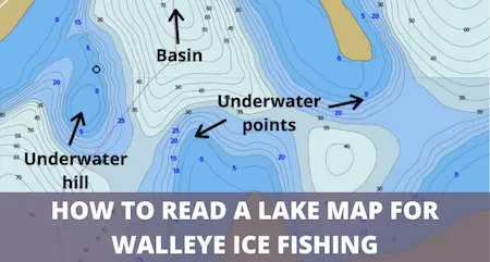
For example, if you see an area where the contour lines show that the bottom is more shallow, that’s an indication that the bottom rises up in that area, maybe in the form of an underwater hill. For example, take a look at the image below:
On the image above, you can see an underwater hill, a deep basin, as well as several underwater points. Once you can identify these structures, the next step is to determine the correct depth range to fish on them.
Highlight a specific depth range
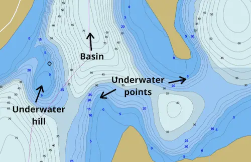
In addition to finding structures likely to attract walleyes, you can also use a contour chart to highlight a specific depth range on those structures, which is another great advantage you have over anglers without this tool.
Let’s say you’ve found an underwater hill that looks like a promising fishing spot. You can then highlight the best depth range to focus your fishing efforts on, and use GPS to navigate there:
Both LakeMaster and Navionics enable you to automatically label a depth range of your choice, which is one of their most useful features.
What to look for on a lake map to find walleye
What features should you look for to find the best ice fishing spots?
This can vary depending on the time of winter and the body of water you’re on (for more details, check out our article on where can you find walleye ice fishing?).
In general, look for these structures:
- Underwater hills, humps, or reefs
- Extensions of shoreline points
- The edges of mudflats with bait fish schools
- Constriction points on travel routes
If you’re fishing during the day in midwinter, look for structures that are close to deeper basins, and try to fish at a depth range of about 20 to 30 feet.
The fish stay in the deep basins during the day, but regularly patrol nearby structure points that are at this depth range.
If you’re fishing at dusk or at night (which are the best times when walleye bite for ice fishing), you should shift your focus to shallower areas of about 8-20 feet depth.
This is because they move into these shallow parts during their active feeding period at night, as this is where most schools of bait fish are to be found.
Finding constriction points on travel routes
Walleye like to move around in groups that patrol large areas of their territory. You can take advantage of this habit by using a contour chart to find spots where their travel routes are constricted into a smaller passage:
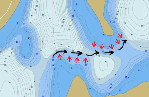
When you find these “choke points,” you can then go on to locate the depth at which fish are active by drilling a row of holes at different depth points, and then doing hole hopping until you mark fish on your flasher or get a bite.
For more details on hole hopping, check out our article on what depth should you ice fish for walleye.
Another option to locate walleye on choke points is by setting up a bunch of tip ups that systematically cover the area until you figure out where the fish are biting. For more information on this, check out our article on how to rig a tip up.
Final remarks
This concludes our article on how to read a lake map for walleye ice fishing.
If you’re ready to find the best fishing spots with a contour chart, you might also be interested in our article on the best ice fishing rod and reel combo for walleye.